
WHERE IT ALL BEGAN
In the early 19th century, people of colour settled along the coast of St Francis Bay, particularly near the river mouths of the Gamtoos, Krom, Eerste, and Storms Rivers. Prior to 1854, a settlement known as “The Fishery” developed into what is now Jeffreys Bay, with the community initially settling on quitrent farmland, later forming the township of Pellsrus.
This self-sufficient and resourceful community relied on fishing as their primary food source, thriving as subsistence fishermen. The area saw rapid population growth between 1800 and 1850 with the allocation of “loan farms” and the rise of farming and trading activities, particularly after Gqeberha (Port Elizabeth) was established as a harbour and trading port.
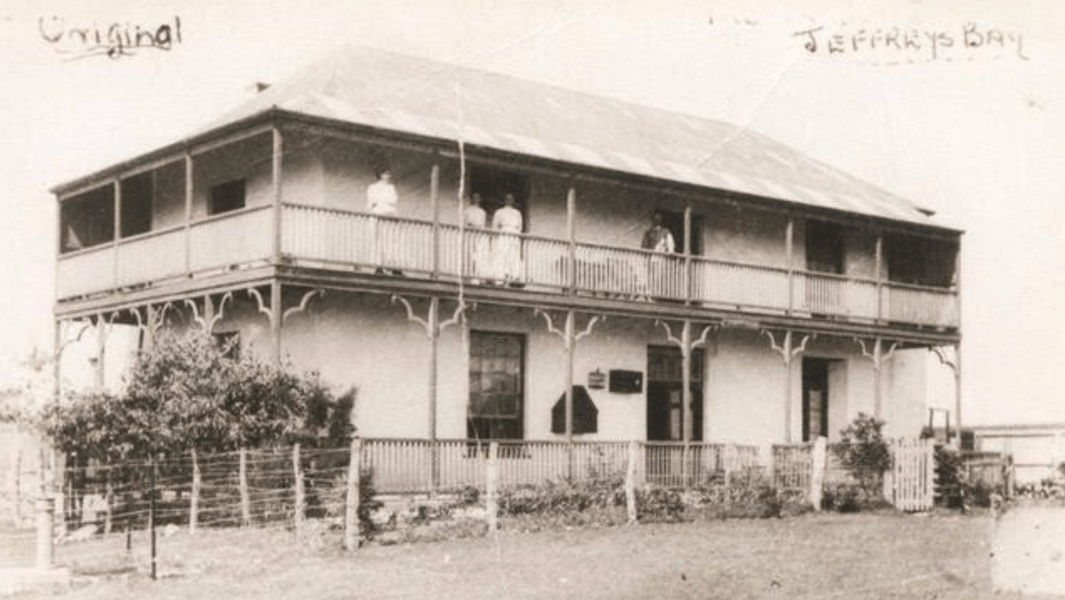
Joseph Avent Jeffery bought the first four plots 1, 2, 9 & 10 for £79.0.0. He erected a double storey, which was later named the “White House”, on plot no 10.
In 1849, Joseph Avent Jeffery built a wood and iron warehouse, marking the first business near Jeffreys Bay. Jeffery and his partner Glendinning initially had a monopoly on coastal trading. With an established fishing community and a natural harbour, trade between Port Elizabeth and Jeffreys Bay opened new markets, especially in Algoa Bay.
By 1852, M G Human and Co. purchased the farm Klein Zeekoe Rivier, and forty coastal erven were put up for sale. Jeffery acquired four plots and constructed a double-storey building known as the “White House.” The Jeffery/Glendinning Company employed local fishermen, who became skilled in using clinker-built rowing boats to transport fish to Gqeberha (Port Elizabeth).
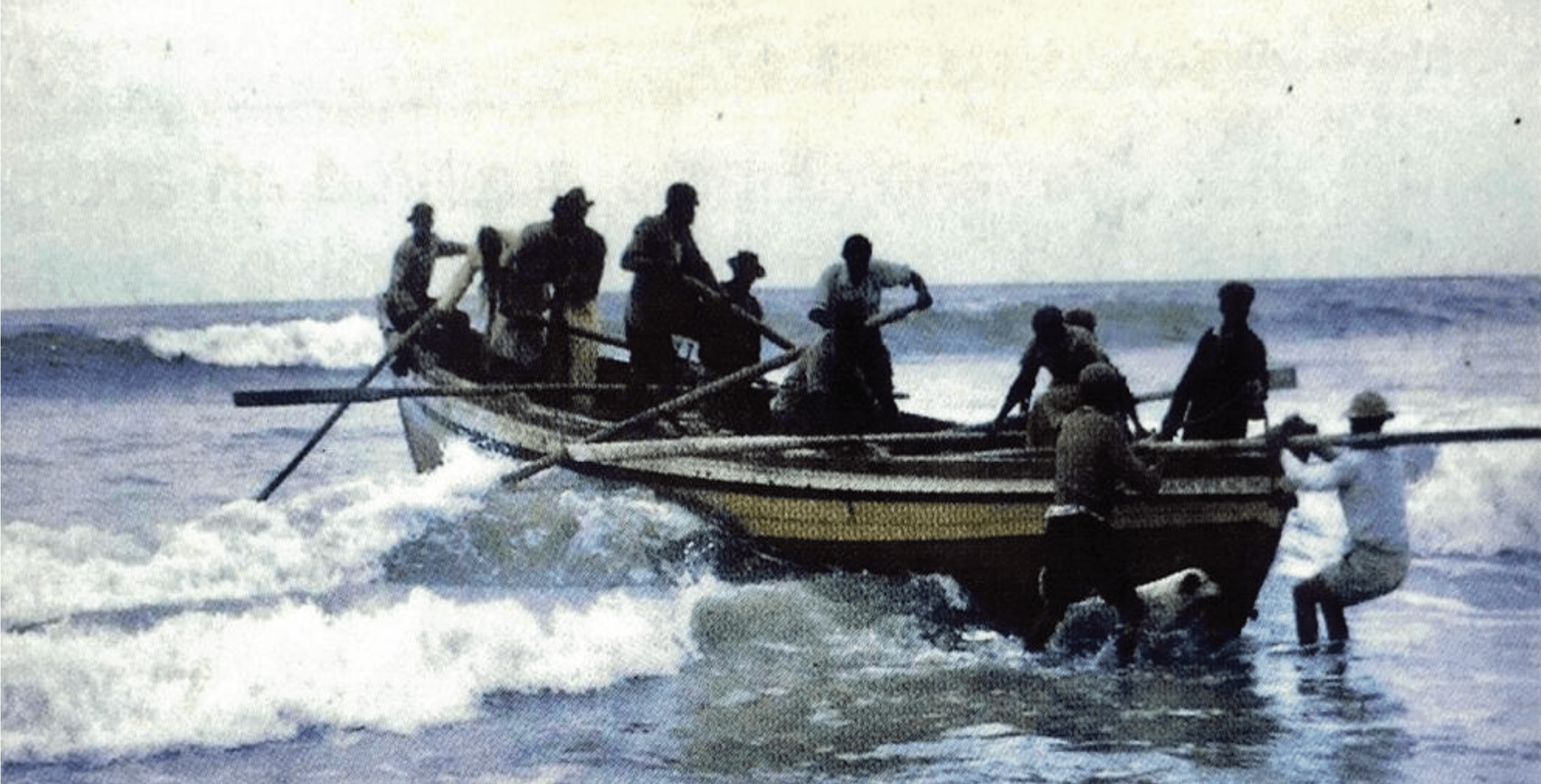
The Jeffery/Glendinning Company obtained rowing fishing boats and employed colored fishermen to man them. They developed into superb fishermen and oarsmen, braving the ocean.
The rowing boats manufactured by the Thesen Company were clinker-built, painted in bright colors, and were of a size that required a crew of eight. The fish and fish products were then transported by boat to Port Elizabeth.
E. J. Gerrytse mentioned that after the establishment of Humansdorp in 1849, the fishing industry in Jeffreys Bay flourished: “…a considerable trade in fish is carried on in the little hamlet which overlooks the roadstead.”
In 1859, four rowing boats were listed, and by 1860, the number had increased to 12, with 72 people actively involved in the fishing industry in the Humansdorp district. All kinds of fish were caught in great numbers, and it was stated that Jeffreys Bay “literally swarms with fish – a large boat has but to go out for three to four hours and return laden to the gunwale.”
By 1860, there was tremendous growth in the fishing industry, providing employment for 72 people. It was reported that the whole bay was teeming with fish and that large rowing fishing boats would regularly return fully laden. By 1892, salted and dried fish valued at approximately £16,722 was exported to Natal and as far afield as Mauritius.
The Re-Echo and Humansdorp Farmers Friend published an article in one of their 1901 issues, which read as follows: “A fisherman who is worth his salt could earn up to 1 pound 10 shillings per day, a princely sum in those days.”
However, most of the people of colour were not boat owners, and a system was in place whereby a boat owner would be entitled to the “boat share”: 1 out of every 6 fish caught, or 1 out of 3 when pickle salt was supplied. The fishermen were entitled to one bunch known as “eat fish”; the rest was sold to the boat owner. Most coloured families really struggled, as they could not even afford to eat all the fish, with some being used to pay for rent in lieu of cash and others traded with farmers for sweet potatoes. (Insert Picture)
Several prominent residents played a role in the fishing industry’s early development between 1914 and 1919, namely: Charles Ockert Hammond; William Pell; Sarah Elizabeth Regnart (widow of John); the Thomas Bros; and R. C. Thomas. By this time, the Thomas Brothers had acquired the “White House,” which they operated as a private hotel and general dealer’s store. A fishery known as Kalk Bay Fisheries was built and operated behind the hotel.
Most of the fishing boats had colourful names. Here are a few, along with the names of their owners and captains:
Poor Man’s Friend: belonging to the Hammonds, Captain Charles October Hammond
Victory: belonging to John Rielly, Captain Berry Hammond
Cecil John: belonging to the Jennekers, Captain Dail Titus
Our Maggie: belonging to Nadassen, Captain William Hammond
Dreadnought: Captain Jors Titus
Alabama: belonging to Marte Ferreira, Captain Record Hammond
Geelstert: Captain Dail Titus, Captain George (“Ou La”) Titus
Ninã: belonging to Emma Wait (Tant Engeltjie), Captain Jonas Perils
St. Francis: belonging to Emma Wait (Tant Engeltjie), Captain Jaap Perils
Additional information regarding Geelstert:
This boat was in service during the 1950’s and 60’s was later purchased by his former captain Mr Dail Titus and the hull section of the boat has been restored and displayed in front of the
Shell Museum.
In 1965 George Pell, an artisan won the tender for repairs and extensions for £1 550.0.0 which had to be done to Government buildings in Humansdorp. His son, William was to play a significant role in the future of Jeffreys Bay. They became shopkeepers and sometimes accepted fish in lieu of payment for products. The Pell House is well-known, and the family members buried in a small cemetery in Pellsrus.
The first postal service between Jeffreys Bay and Humansdorp comes into effect in 1901.
In 1902 Charles Papenfus builds the Beach Hotel (today Seashells Apartments).
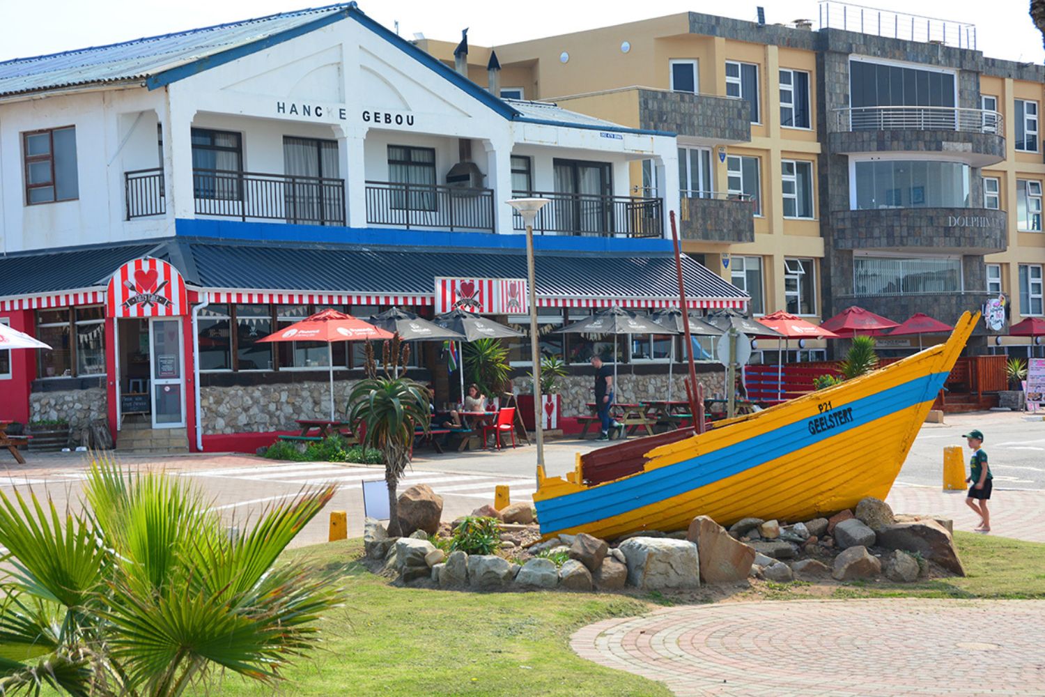
Geelstert on display today
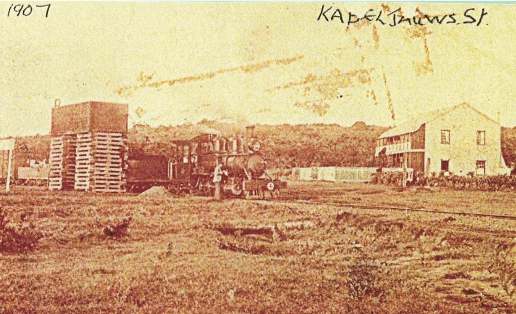
In 1905 the first Railroad linking Jeffreys Bay and Port Elizabeth came into effect, but the line ended on the eastern bank of the Kabeljouws River.
In 1906 J W and Sarah Regnart built the Jeffreys Bay Hotel (today Savoy Hotel). The same trade has been carried out in these premises for over 100 years.
The village of Jeffreys Bay was run by a Local Board and in 1918 had only 15 names on the voters roll.
The inauguration date of the Jeffreys Bay Primary School was 1st January 1919. The first school building was erected in 1924.
Voting took place in February 1926 and three Members of the first Local Council elected.
The Council of Jeffreys Bay was officially declared a Village Management Board in October 1930.
The first resident Doctor, Dr. M Herholdt settled in Jeffreys Bay in 1955.
Motorised fishing boats were introduced in 1952, soon doing away with the rowing/sailing boats and boatsmen. Now all board could concentrate on catching fish and in 1963 the first cold storage facility was set up in town. This helped the fishermen to market their catches further afield.
The small community of trek-net and line fishermen who operated these boats tended to live in a tight-net community close to the beach and right into the 1980’s many of them still relied heavily on the sea for their living.
In 1966 the first library opened its doors.
On the 3rd of January 1968, Jeffreys Bay became a Municipality and Councillor C J Greef was appointed as the first Mayor.
A much bigger change was on the horizon that would have a dramatic impact not only on the fishing community but on the town itself. Almost overnight, exploitation of the vast shoals of squid (“Chokka”) off the coast became a lucrative industry and fortune-seekers from all walks of life descended on Jeffreys Bay. The era of the old clinker-built double-enders was over.
In 1997 the boats moved over to the newly opened harbour of Port St Francis, situated some 40 km away from Pellsrus and meant the end of the local fishing industry.
Die Shell Museum opened on 15 September 1998 displaying the collection of Me Charlotte Isabella Kritzinger.
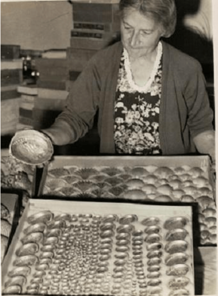
Me Charlotte Kritzinger
In 2002 the municipalities of seven towns in the St. Francis Bay Region merged and became known as Kouga Municipality.
Today Jeffreys Bay is a flourishing town with many permanent residents and during holidays bustle with holidaymakers.
JEFFREYS BAY SURF
- Jeffreys Bay is world renowned for its safe beaches and surfing waves, with many different surf breaks, each possessing its own magic.
- Surfing spots include Kitchen Window, Tubes, Super Tubes, Point, Lower Point, Magna Tubes and Albatross.
- The waves at Super Tubes can get up to about 10 – 12 feet. They are very fast, and as the name suggests, getting tubed is the name of the game. The swell usually runs in the winter months.
- Boneyards is right next to Supers. You will be able to recognise it with ease, as it is the spot where the waves are breaking almost perfectly.
- Point is situated east of Super Tubes, further down the beach. The waves here tend to be a little smaller than those at Boneyards and Supers. Here you can expect a much longer ride than Boneyards and Super Tubes.
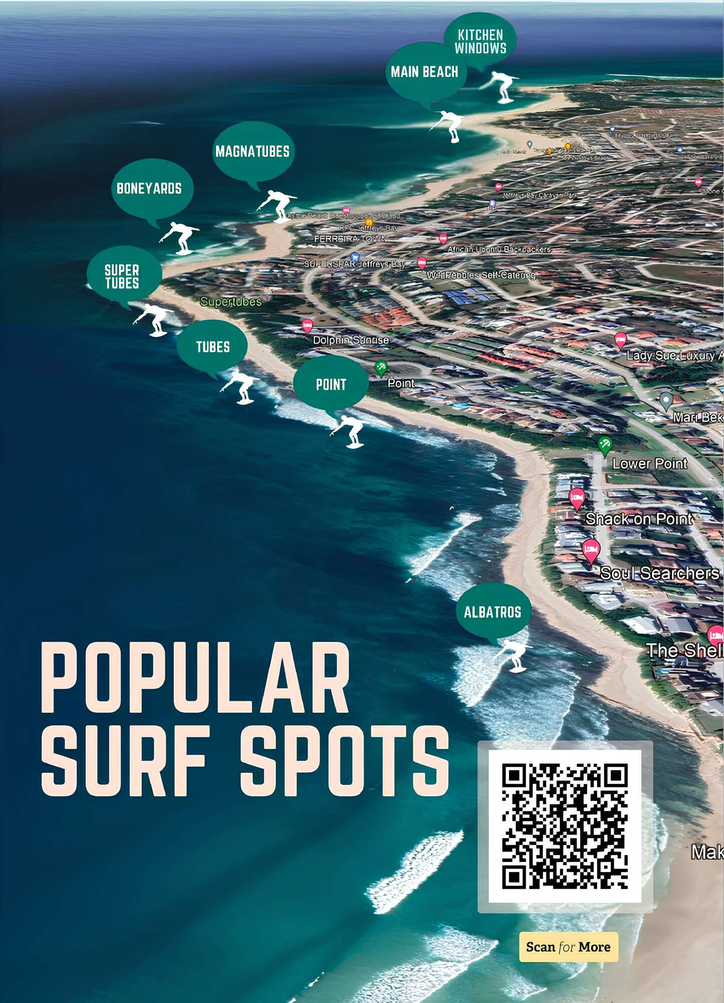
Viewing on your phone? Follow this link for the Google Map.

FAUNA AND FLORA
Jeffreys Bay’s beaches are abundant with shells and are renowned for excellent angling. Fishing in Jeffreys Bay can yield Cob, Leerfish (Garrick), Grunter, White Steenbras, Blackmail, Musselcracker, Baardman, Red Steenbras, Poenskop, Roman, Dageraad, Elf, various shark species, and rays.
Nature enthusiasts will enjoy the recreational activities offered by the three nature reserves managed by Cape Nature Conservation. Despite their small size, these reserves provide peace and tranquility along with hiking trails. Additionally, hikers can explore the Kabeljous Nature Reserve and nearby trails in the Cape St Francis Nature Reserve, Baviaanskloof, and Tsitsikamma.


COMMERCE
Jeffreys Bay is home to thriving handcraft industries. The town is synonymous with surf culture, and its clothing shops often feature scenes from Jeffreys Bay. Other attractions include surf shops, handcrafted leather shoes, shell art, and a craft beer brewery. Additionally, Jeffreys Bay is the hub of the Eastern Cape’s calamari industry, allowing it to provide visitors with this delicacy in abundance.

THE WEATHER
- Temperatures are moderate all year round along the coast, with rain scattered throughout the year.
- Summers: Warm with a very temperate humidity level.
- Winters: Mild and pleasant, and it is significant that water sports are practised year-round.
- Jeffreys Bay normally receives about 427mm of rain per year, with rainfall occurring throughout the year.
- It receives the lowest rainfall (25mm) in January and the highest (43mm) in October. The region is the coldest during July where the average midday temperatures is 19°C and warmest in February at 28°C.

FOLLOW US

